Congress funded the cleanup of America's abandoned mines, but the list
of what needs cleaning is incomplete — the GAO has said so directly. Today that list
grows by hand, one quadrangle at a time. We read public LiDAR and find what's missing.
coal-hazard features in the federal inventory (e-AMLIS)
~530,000
estimated abandoned mines on public lands alone
$11.3 B
in federal infrastructure funding for mine-land reclamation
Reclamation money gets spent on the hazards agencies know about, and it's budgeted by
the acre. Most state inventories track hazard points rather than the disturbed land
around them, and a hazard that was never recorded isn't in line for funding at all.
That's the gap we work on.
What we deliver
Three deliverables, every engagement
Deliverable 1
A ranked hazard shortlist
Candidate undocumented hazards: openings, highwalls, spoil and refuse, subsidence.
Each one is independently verified before it reaches you, comes with written
evidence, and is sorted so field crews can start with the most likely sites.
Deliverable 2
Disturbance acreage, mapped
The full extent of mine-disturbed land, wall to wall. In our Pennsylvania study
belt that came to 6.1× the acreage in the official polygons — and acreage is
the number reclamation budgets actually run on.
Deliverable 3
Data that drops into your systems
Everything arrives in your schema — e-AMLIS-compatible records, GIS layers your
staff already know how to use, and the evidence chain behind every entry.
Results · July 2026 evaluation
We kept testing it farther from home
Any detector looks good on its home turf. The question that matters is what happens
somewhere new — so we evaluated across ten sites in four states, including counties and
entire terrain types the model never trained on:
Home region — Schuylkill Co., PAanthracite; the terrain it knows best
99%
Never-trained county — Belmont Co., Ohiodifferent state, different records system
95%
Never-trained county — Cambria Co., PAno training data from this county
90%
Never-trained county — Logan Co., WVthe steepest terrain we evaluate; 94% within 150 m
85%
Never-trained terrain — Greene Co., PAdeep-mine province: subsidence and refuse, not strip benches
97%
Never-trained terrain — Clay Co., Indianaflat, glaciated midwest strip country
89%
Share of officially inventoried hazards
independently re-found from LiDAR alone, at matched settings (July 2026, 10-site
evaluation). Detector accuracy (ROC-AUC, held out): 0.91 on four-state training.
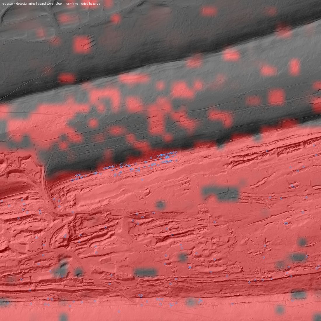
Home region. Schuylkill County, PA.
Red is our detection;
blue rings are the state's
records. The detections track the disturbed mine terrain, stay dark on untouched
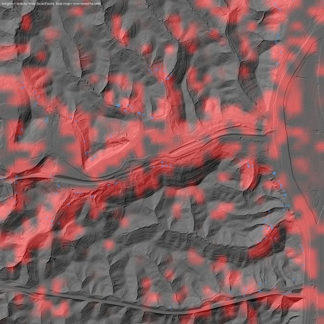
ridges, and extend well past where the point inventory stops.Never-trained state. Belmont County, Ohio — contour strip-mine
country the model has no training data for. It re-found 95% of the state's
inventoried hazards.
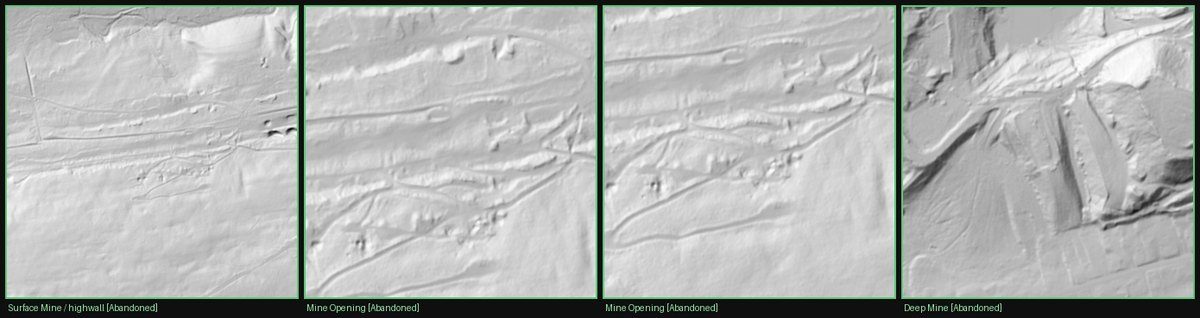
Why this works at all. Four inventoried Pennsylvania hazards as
LiDAR sees them — a highwall, two clusters of mine openings, a deep mine. Trees grow
back in thirty years; a highwall is still a cliff a century later. The ground
remembers, even where aerial photos show nothing but canopy.
What wasn't on anyone's list
6.1×
more disturbance acreage than the polygon inventory records (19,199 ac vs 3,155 ac in the study belt)
~4,700 ac
verified mine disturbance far from any inventory record, in one 100 km² sample
92%
of flagged disturbance near the mining belt held up under independent verification review
What we don't claim
A verified flag is still not a field visit. Final confirmation belongs to human
crews, and everything we deliver is built with that in mind. The steepest Appalachian
terrain is the hardest case — Logan County's 85% rises to 94% within a 150 m tolerance,
and the residual misses are features with little surface expression left (collapsed
portals, regraded mines). Some evaluation counts are small (Cambria: 31 hazards), so
we quote them with that caveat. And county-wide projections are estimates, labeled as
such.
Free pilot. You pick the ground.
Choose an area your team knows well. We'll scan it at no cost and hand over
everything we find, and you can tell us what we got right and what we missed. If the
results are useful, we can talk about what comes next.